Python with ArcPy package
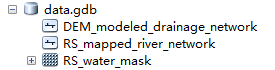
DEM-modeled drainage network.shp: the DEM-modeled drainage network polylineRS-mapped river network.shp: the river centerlines of the RS water body mask. We used the river detection method proposed by Kang Yang (https://github.com/njuRS/River_detection.git). You can use the customed RS water body mask instead.RS water mask.tif: the binary water body mask, water is set to 1, non-water is 0

In order to ensure this code runs correctly, please make sure the coordinates are consistent
Create a File Geodatabase.gdb and import the three files in it. All process data will be saved in this database.

- Open
connect_river.pyin Python. - Set input 6 parameters.
| parameters | description |
|---|---|
| workspace | the path of the geodatabaseset |
| DEM | the name of the DEM-modeled drainage network |
| RS_vector | the name of the RS-mapped river centerlines |
| RS_Raster | the name of the RS binary water body mask |
| cell size | the cell size of the images, Sentinel-2 imagery is 10 |
| delete_length | river length less than 300 m will be deleted |
-
Click run.
-
These two shapefiles in the red box are the result.
unspit_split_coincide + DEM name.shpis the RS-mapped river segments, andunspit_split_connect + DEM name.shpis the DEM-modeled river segments.


Lu, X., Yang, K., Lu, Y., Gleason, C.J., Smith, L.C., & Li, M. (2020). Small Arctic rivers mapped from Sentinel-2 satellite imagery and ArcticDEM. Journal of Hydrology, 584, 124689
- Xin Lu (xinlu.nju@gmail.com, ph:15951756762, School of Geography and Ocean Science, Nanjing University)
- Kang Yang (kangyang@nju.edu.cn, School of Geography and Ocean Science, Nanjing University)
- Yao Lu (yaolu.nju@gmail.com, School of Geography and Ocean Science, Nanjing University)